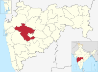
Kopargaon
Appearance
(Redirected from Kopargoan)
This article possibly contains original research. (May 2019) |
Kopargaon | |
|---|---|
Town | |
| Coordinates: 19°53′06″N 74°28′41″E / 19.885°N 74.478°E | |
| Country | |
| State | Maharashtra |
| District | Ahmadnagar |
| Elevation | 493 m (1,617 ft) |
| Population (2011) | |
• Total | 65,273 |
| Languages | |
| • Official | Marathi |
| Time zone | UTC+5:30 (IST) |
| Vehicle registration | MH17 |
Kopargaon is a town and municipality located in the Ahmednagar district of the Indian state of Maharashtra.[1]
Geography
[edit]Kopargaon is situated at 19°53′N 74°29′E / 19.88°N 74.48°E. It has an average elevation of 593 meters (2,117 feet) and lies on the banks of the Godavari River.
Demographics
[edit]In the India census of 2011,[2] The town of Kopargaon had a population of 65,273, of which 51% was male and 49% female. Thirteen percent of the population is under 6 years of age. Kopargaon has a literacy rate of 69%. Male literacy is 76%, female literacy is 62%. This compares favorably with the national literacy ratio of 59.5%.
References
[edit]- ^ "Municipalities | Ahmednagar | India". Official website of Ahmednagar District Administration. National Informatics Centre. 5 March 2024. Retrieved 5 March 2024.
- ^ "Census of India 2001: Data from the 2001 Census, including cities, villages and towns (Provisional)". Census Commission of India. Archived from the original on 16 June 2004. Retrieved 1 November 2008.


